
China Provinces & Regions: A Traveler's Guide to China's Administrative Divisions
Understand China's 23 provinces, 5 autonomous regions, 4 municipalities, and 2 SARs. A clear guide to China's size and regional differences for travelers.
China's Size & Administrative Regions
Booking a trip to China isn't like planning a weekend in Paris. This country spans an entire continent's worth of geography, cultures, climates, and cuisines. Understanding how China is organized — its sheer size, its regional divisions, and what makes each part unique — will transform how you plan your journey.
How Big Is China?
Let's start with the number that surprises almost everyone: China covers approximately 9.6 million square kilometers (3.7 million square miles). Here's what that actually means:
| Comparison | Equivalent |
|---|---|
| United States | Roughly the same size (China is ~2% smaller than the US including Alaska) |
| Europe | About the same area as the entire European continent |
| United Kingdom | ~40 times the size of the UK |
| France | ~17 times the size of France |
| Japan | ~25 times the size of Japan |
East to West, North to South
China stretches roughly 5,200 km from east to west and 5,500 km from north to south. If you superimposed China onto a world map:
- Flying from Shanghai (east coast) to Kashgar (far west) takes about 6 hours — roughly the same as flying from London to Dubai
- Driving from Beijing (north) to Haikou (south) covers more distance than driving from Seattle to Miami

Why Size Matters for Your Trip
| Factor | Impact on Travel |
|---|---|
| Climate | In January, Harbin (northeast) can hit -30°C while Sanya (south) basks at 25°C. Pack for your specific destinations, not for "China." |
| Time Zone | Despite spanning 5 geographic time zones, all of China uses Beijing Time (UTC+8). In Xinjiang, the sun sets around 10 PM in summer. |
| Cuisine | Food changes radically by region — spicy in Sichuan, sweet in Shanghai, hearty wheat-based in the north, delicate dim sum in the south. |
| Culture & Language | While Mandarin unifies the country, regional dialects, customs, and festival traditions vary enormously — traveling across China can feel like crossing multiple countries. |
Understanding the Administrative System
China has a four-tier administrative hierarchy. At the top — directly under the central government — are 34 province-level divisions:
| Type | Count | Examples | What Makes It Special |
|---|---|---|---|
| Province (省) | 23 | Guangdong, Sichuan, Yunnan | Standard administrative unit; most of China's land and population |
| Autonomous Region (自治区) | 5 | Tibet, Xinjiang, Guangxi | Has a significant ethnic minority population; enjoys some cultural autonomy |
| Municipality (直辖市) | 4 | Beijing, Shanghai | A mega-city administered directly by the central government |
| Special Administrative Region (特别行政区) | 2 | Hong Kong, Macau | Separate legal, economic, and border systems under "One Country, Two Systems" |
For travelers, this hierarchy matters because:
- Autonomous Regions may require special permits (especially Tibet)
- SARs have separate visa policies, currencies (Hong Kong Dollar, Macanese Pataca), and border controls
- Municipalities are often the easiest entry points for international flights
The 23 Provinces — A Region-by-Region Guide
China's provinces are traditionally grouped into seven geographic regions. Here's each one, with its capital and a one-sentence highlight for travelers.

North China (华北)
| Province | Chinese | Capital | Why Visit |
|---|---|---|---|
| Hebei | 河北 | Shijiazhuang | Surrounds Beijing — contains the eastern end of the Great Wall at Shanhaiguan |
| Shanxi | 山西 | Taiyuan | Ancient merchant cities (Pingyao), the Yungang Grottoes, and knife-cut noodles |
Northeast China (东北)
| Province | Chinese | Capital | Why Visit |
|---|---|---|---|
| Liaoning | 辽宁 | Shenyang | Former Manchu imperial capital; Dalian's Russian-influenced coastal charm |
| Jilin | 吉林 | Changchun | Winter wonderland — Jilin's rime ice trees and Changbai Mountain on the North Korean border |
| Heilongjiang | 黑龙江 | Harbin | The world-famous Harbin Ice Festival and Russian architectural heritage |
East China (华东)
| Province | Chinese | Capital | Why Visit |
|---|---|---|---|
| Jiangsu | 江苏 | Nanjing | Classical gardens of Suzhou, Nanjing's Ming Dynasty history, and exquisite Jiangsu cuisine |
| Zhejiang | 浙江 | Hangzhou | West Lake, ancient water towns, and Longjing tea plantations |
| Anhui | 安徽 | Hefei | The otherworldly Huangshan (Yellow Mountains) and well-preserved Huizhou villages |
| Fujian | 福建 | Fuzhou | Tulou (circular Hakka earth buildings), Wuyi Mountain tea, and Xiamen's laid-back island vibe |
| Jiangxi | 江西 | Nanchang | Jingdezhen — the porcelain capital of the world — and misty Lushan Mountain |
| Shandong | 山东 | Jinan | Birthplace of Confucius (Qufu), Tsingtao beer, and sacred Mount Tai |
Central China (华中)
| Province | Chinese | Capital | Why Visit |
|---|---|---|---|
| Henan | 河南 | Zhengzhou | Shaolin Temple, the cradle of kung fu, and the Longmen Grottoes |
| Hubei | 湖北 | Wuhan | The Three Gorges, Yellow Crane Tower, and Wuhan's bustling breakfast culture |
| Hunan | 湖南 | Changsha | Fiery Hunan cuisine, Zhangjiajie's floating Avatar mountains, and Chairman Mao's hometown |
South China (华南)
| Province | Chinese | Capital | Why Visit |
|---|---|---|---|
| Guangdong | 广东 | Guangzhou | Cantonese dim sum, Shenzhen's tech energy, and the Lingnan cultural heritage |
| Hainan | 海南 | Haikou | China's tropical island paradise — beaches, surf, and duty-free shopping |
| Guangxi (listed in Autonomous Regions) | — | — | See below |
Southwest China (西南)
| Province | Chinese | Capital | Why Visit |
|---|---|---|---|
| Sichuan | 四川 | Chengdu | Giant pandas, fiery hot pot, and the Leshan Giant Buddha |
| Guizhou | 贵州 | Guiyang | Otherworldly karst landscapes, Miao and Dong minority villages, and China's fastest-growing tech hub |
| Yunnan | 云南 | Kunming | Shangri-La mystique, the ancient Tea Horse Road, and 25+ ethnic minority cultures in one province |
Northwest China (西北)
| Province | Chinese | Capital | Why Visit |
|---|---|---|---|
| Shaanxi | 陕西 | Xi'an | The Terracotta Warriors and the starting point of the ancient Silk Road |
| Gansu | 甘肃 | Lanzhou | Rainbow-colored Danxia landforms, Mogao Caves of Dunhuang, and hand-pulled beef noodles |
| Qinghai | 青海 | Xining | Vast Tibetan grasslands, the source of the Yangtze and Yellow Rivers, and China's largest lake |
The 5 Autonomous Regions
Autonomous Regions (自治区) are province-level divisions established in areas with large ethnic minority populations. They're named after the dominant minority group and offer some of China's most culturally immersive travel experiences.
| Autonomous Region | Chinese | Capital | Ethnic Focus | Travel Highlight |
|---|---|---|---|---|
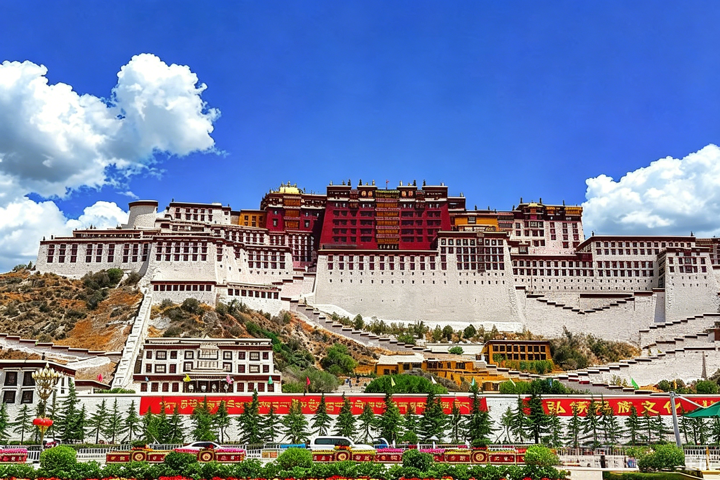
| Tibet | 西藏自治区 | Lhasa | Tibetan | Potala Palace, Jokhang Temple, high-altitude Himalayan landscapes |
| Xinjiang | 新疆维吾尔自治区 | Ürümqi | Uyghur, Kazakh, Kyrgyz | Silk Road cities (Kashgar, Turpan), Heavenly Lake, vast deserts |
| Guangxi | 广西壮族自治区 | Nanning | Zhuang | Guilin's karst peaks, Longji Rice Terraces, Li River cruises |
| Inner Mongolia | 内蒙古自治区 | Hohhot | Mongol | Endless grasslands, Naadam Festival, yurt homestays |
| Ningxia | 宁夏回族自治区 | Yinchuan | Hui (Muslim Chinese) | Shapotou Desert, Xixia Imperial Tombs, halal food culture |
The 4 Municipalities
Municipalities (直辖市) are massive cities that report directly to the central government rather than to a surrounding province. Each functions as its own province-level entity.
| Municipality | Chinese | Population | For Travelers |
|---|---|---|---|
| Beijing | 北京 | ~22 million | The political and cultural heart — Forbidden City, Great Wall, Temple of Heaven, and your most likely entry point |
| Shanghai | 上海 | ~25 million | China's glamorous financial capital — the Bund, French Concession, and the world's busiest container port |
| Tianjin | 天津 | ~14 million | Beijing's port city neighbor — colonial-era European architecture and a relaxed, food-obsessed culture |
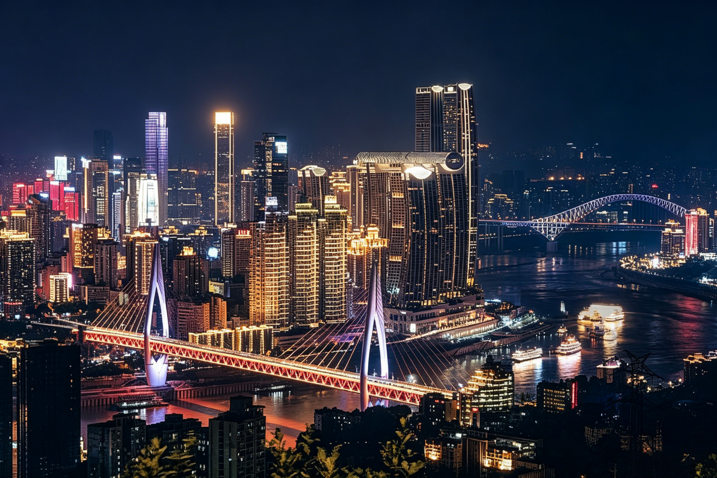
| Chongqing | 重庆 | ~32 million | A sprawling mountain megacity — fiery hot pot, dramatic river gorges, and cyberpunk-like layered urban landscapes |
About three-quarters of international flights to China land at Beijing, Shanghai, or Guangzhou — which means you'll almost certainly pass through one of these municipalities.
The 2 Special Administrative Regions
Hong Kong and Macau operate under the principle of "One Country, Two Systems" (一国两制). For travelers, this means they function almost like separate countries in terms of border controls, visas, and currency.
| Feature | Hong Kong | Macau |
|---|---|---|
| Visa Policy | Separate from mainland China; most Western nationals get 7–180 days visa-free | Separate; most nationalities get 30–90 days visa-free |
| Currency | Hong Kong Dollar (HKD) | Macanese Pataca (MOP) — HKD widely accepted |
| Language | Cantonese, English (both official) | Cantonese, Portuguese (official), Mandarin |
| Entering Mainland | Requires a Chinese visa (unless transit- or visa-free eligible) | Same; crossing into Zhuhai requires valid mainland entry documents |
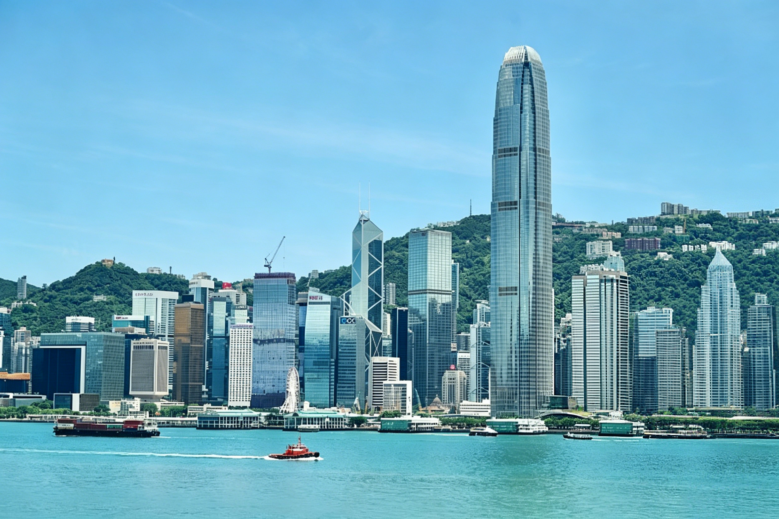
| Best Known For | Skyline, dim sum, Victoria Peak, shopping | Portuguese colonial heritage, casinos, egg tarts, cobblestone lanes |
Why SARs Matter for Travelers
- Visa Reset: Hong Kong and Macau count as international destinations. If you hold a single-entry Chinese visa and travel to Hong Kong, you can't re-enter mainland China on the same visa — you'll need a multiple-entry visa or a new one.
- Transit Loophole: Flying into Hong Kong and crossing into Shenzhen (mainland) can be an easier entry strategy for some nationalities, especially if you're eligible for the Guangdong 144-hour visa-free scheme.
- Cash Difference: You'll need Hong Kong Dollars in Hong Kong and RMB in the mainland. ATMs are plentiful at the border for quick withdrawals.
Why This Matters for Travelers
Understanding China's regional structure isn't just geography trivia — it directly affects your trip planning:
| Consideration | Example |
|---|---|
| Climate Planning | A January itinerary that includes both Harbin (Ice Festival, -25°C) and Sanya (beach, +25°C) requires packing for two extreme seasons |
| Visa Strategy | If your trip includes Tibet, you need a Chinese visa plus a Tibet Travel Permit — start the permit process at least 3 weeks before departure |
| Route Logic | A Beijing → Xi'an → Chengdu route follows a natural geographic and cultural progression; Beijing → Guilin → Harbin involves unnecessary backtracking |
| Festival Timing | The Harbin Ice Festival (Jan–Feb), Naadam Festival in Inner Mongolia (July), and Water Splashing Festival in Yunnan (April) all happen in different seasons and regions |
| Altitude Acclimatization | If traveling to Tibet (3,600m+), build your itinerary so you ascend gradually — fly into Xining (2,200m) or Kunming (1,900m) first before heading higher |
Ready to Explore?
China's 34 province-level divisions each tell a different story — from the frozen rivers of Heilongjiang to the tropical shores of Hainan, from Shanghai's neon canyon streets to Tibet's silent prayer-flag-draped passes.
Next up in your trip planning:
- 🏙️ Browse our city guides — detailed walkthroughs for Beijing, Shanghai, Chengdu, Xi'an, and Guilin
- 🌍 Meet China's ethnic groups — discover the cultures, festivals, and villages of 56 ethnic groups
- 📋 Check visa requirements — whether you can enter visa-free or need an L Tourist Visa
Which region of China interests you most?
Tell us in the comments — are you drawn to the ancient capitals of the north, the karst landscapes of the south, the Silk Road cities of the west, or the futuristic skylines of the east? We'll share personalized tips!
Related Articles
China at a Glance: Fast Facts, Geography, People & Travel Essentials
Everything you need to know before traveling to China — size, population, ethnic groups, language, time zones, currency, and more. Your complete China overview for 2026.
China's 56 Ethnic Groups — A Cultural Guide for Travelers
Discover the rich diversity of China's 56 ethnic groups. Learn about Zhuang, Hui, Tibetan, Uyghur, Mongolian, Miao cultures and the best regions to experience them.
Chinese Food Culture: 8 Great Cuisines & What Every Traveler Must Eat
Dive into China's 8 great cuisines, must-try dishes, local eating customs, table manners, and tips for vegetarians and halal travelers. Your ultimate food guide to China.